The Causeway: Difference between revisions
No edit summary |
No edit summary |
||
| Line 88: | Line 88: | ||
== Historical Notes == | == Historical Notes == | ||
{{Fee Farm}} | {{Fee Farm}} | ||
Revision as of 22:11, 29 August 2024
| HINCHLEY WOOD | ||||||||
| E | 🏘️ | 🚂 | 🏘️ | 🌳 | 🌳 | 🌳 | 🌳 | C |
| S | 🏘️ | 🚂 | 🏘️ | 🌳 | 🏘️ | 🌳 | 🌳 | H |
| H | 🌳 | 🚂 | 🛒 | 🛒 | 🏘️ | 🏘️ | 🏘️ | E |
| E | 🌳 | 🚂 | 🏘️ | ✞ | 🏘️ | 🏘️ | S | |
| R | 🌳 | 🚂 | 🌳 | 🏘️ | 🌳 | 🌳 | 🚗 | S |
| 🌳 | 🚂 | 🌳 | 🏘️ | 🚗 | 🚗 | 🌳 | N | |
| OXSHOTT | ||||||||
Briarwood
- Briarwood, The Causeway, KT10 0NE — 2020/3283 — PROPOSAL: Conversion of garage into living space incorporating alterations to fenestration. — COUNCIL RESPONSE: No objection, no comment. (PARISH COUNCIL PLANNING MEETING 5-JAN-21)
- Briarwood, The Causeway KT10 0NE — 2021/0212 — PROPOSAL: Conversion of garage into living space with external alterations. — COUNCIL RESPONSE: No objection, No comment (PARISH COUNCIL PLANNING MEETING 25-FEB-21)
Elm Cottage
- Elm Cottage, The Causeway KT10 0NE — 2021/0001 — PROPOSAL: Single-storey rear outbuilding. — COUNCIL RESPONSE: No objection with two comments:
- 1/ CPC would like reassurance that the large tree located right next to the planned outbuilding will not be affected by any foundations put in place.
- 2/ CPC note that the outbuilding proposed is in very close proximity to 26 Blakeden Drive. (PARISH COUNCIL PLANNING MEETING 25-FEB-21)
The Oaks
- The Clerk had received notification that an unauthorised development of a fence and car port at The Oaks, The Causeway, KT10 0NE had now been resolved. The carport has now been removed and the fences reduced to a height to bring it within the requirements of The Town and Country Planning (General Permitted Development) (England) 2015 Schedule 2, Part 2, Class A. (PARISH COUNCIL PLANNING MEETING 5-NOV-20)
The area
| AP66 MS to send photos to Clerk of overgrown hedge on right hand side of exit of Cornwall Avenue into The Causeway is causing line-of-sight issues. Clerk to notify SCC. DONE. Informed Liz Shakiri on 10th Sept. Cllr Lesser confirmed it had been actioned. (PARISH COUNCIL HT&E MEETING 11-FEB-21) |
| AP85 A resident had raised two concerns. One being a water leakage on The Causeway and the second regarding a pothole at the Common Road bus stop. MS to send Clerk details so she can raise with SCC. OUTSTANDING. (PARISH COUNCIL H&TE MEETING 10-DEC-20) |
Historical Notes
Fee Farm
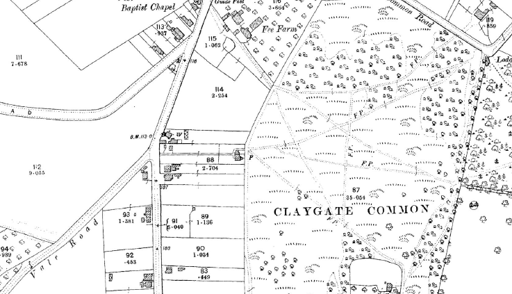
In the latter part of the 19th century Fee Farm comprised about seven acres of which nearly three acres were orchards, and the rest mainly meadow and arable land. It had a cottage, the usual farm buildings and a paddock. The area covered by the farm was bounded on the east by The Causeway and Coverts Road, on the south and north by what later became Woodlands Close and Cornwall Avenue respectively, and on the west by Claygate Common. It is quite possible of course that the farm was somewhat larger in earlier times, as in 1838, when James Scott was the tenant, the farm had a rateable value of £21 which would have been rather excessive for a farm of that size.
On the farmland, opposite the 'Corner Shop' and roughly where the house called 'Two Trees' now stands, was a smith's shop and a yard built some time before 1709 by John Romain. In 1709 it was occupied by the widow of Richard Perkins for a yearly rent of 2s.6d. for 41 years, subsequently by William Wood, then by John Woodlatch, and finally by Stephen Humphrey who obtained a seven-year lease of the shop in September 1893. In that year, and for at least the previous 20 years, James Taylor was the tenant farmer, but in the following year Edward Dalton took over the tenancy, while the Foley family were the landlords.
In April 1920, Lord Gerald Henry Foley sold Fee Farm and its land, including the shop, to George and Rundle Brendon for £1,300. They in turn sold it to Percy and Charles Mitchell of Seaton, Devon, for £2,750 in October 1923. The Mitchell brothers were builders and in the late 1920s/1930s Fee Farm Road was created, but not made up, and houses were gradually built along either side of it. Fortunately, the farmhouse itself survived and was not demolished for redevelopment as might easily have been the case in those days when the preservation of old buildings was not so controlled as it is today.
In the mid 1930s, a strip of land on the northern boundary of the farm was acquired by Esher Urban District Council to create an easier and safer access to Common Road from The Causeway. This short stretch of road was built in 1938 and named Cornwall Avenue after an adjacent house called Cornwall House, which together with Newlyn, had been built two years beforehand. Most of the houses along this road were given West Country names, presumably either at the inspiration of the Mitchells who came from Devon, or perhaps because the householders thought that West Country names would harmonise with the name of this road.

Source
- Peebles, Malcolm (1983). The Claygate Book. (Millennium edition). Stockbridge: by BAS Printers Ltd. ISBN 0-9508978-0-9.

- Many thanks also for the photos, many supplied by Terry Gale, from the Claygate Local History Facebook group.

