Coverts Road: Difference between revisions
| Line 80: | Line 80: | ||
[https://emaps.elmbridge.gov.uk/ebc_planning.aspx?requesttype=parsetemplate&template=PlanningDetailsTab.tmplt&basepage=ebc_planning.aspx&Filter=%5eAPPLICATION_NUMBER%5e=%272024/2614%27&history=72b86d68898a460ca9ee4c10378e70c7&appno:PARAM=2024/2614&address:PARAM=153%20Coverts%20Road%20Claygate%20Esher%20Surrey%20KT10%200LE&easting:PARAM=515811&northing:PARAM=162737 {{sc|view details}}] | [https://emaps.elmbridge.gov.uk/ebc_planning.aspx?requesttype=parsetemplate&template=PlanningDetailsTab.tmplt&basepage=ebc_planning.aspx&Filter=%5eAPPLICATION_NUMBER%5e=%272024/2614%27&history=72b86d68898a460ca9ee4c10378e70c7&appno:PARAM=2024/2614&address:PARAM=153%20Coverts%20Road%20Claygate%20Esher%20Surrey%20KT10%200LE&easting:PARAM=515811&northing:PARAM=162737 {{sc|view details}}] | ||
{{plan-app-decid|<!-- 1. APPLICATION NUMBER -->2024/2614|<!-- 2. ADDRESS -->153 [[Coverts Road]]|<!-- 3. PROPOSAL --> Hip-to-gable roof extension incorporating L-shaped rear dormer window and front rooflights.|<!-- 4. CPC VERDICT --> No Comment.|<!-- 5. EBC DECISION -->Grant Lawful Development Cert - Proposed.}} | |||
[https://emaps.elmbridge.gov.uk/ebc_planning.aspx?requesttype=parsetemplate&template=PlanningDetailsTab.tmplt&basepage=ebc_planning.aspx&Filter=%5eAPPLICATION_NUMBER%5e=%272024/2614%27&history=e155e8a7f6604c7d987d58b4faa80fc8&appno:PARAM=2024/2614&address:PARAM=153%20Coverts%20Road%20Claygate%20Esher%20Surrey%20KT10%200LE&easting:PARAM=515811&northing:PARAM=162737 {{sc|view details}}] | |||
=== № 160 === | === № 160 === | ||
{{plan-app-comm|<!-- 1. APPLICATION NUMBER -->2024/2331|<!-- 2. ADDRESS -->160 [[Coverts Road]]|<!-- 3. PROPOSAL --> Two-storey side extension incorporating integral garage and single storey rear extension following partial demolition of existing house.|<!-- 4. COMMENTS -->Householder Application}} | {{plan-app-comm|<!-- 1. APPLICATION NUMBER -->2024/2331|<!-- 2. ADDRESS -->160 [[Coverts Road]]|<!-- 3. PROPOSAL --> Two-storey side extension incorporating integral garage and single storey rear extension following partial demolition of existing house.|<!-- 4. COMMENTS -->Householder Application}} | ||
Latest revision as of 23:12, 12 December 2024
| H I N C H L E Y W O O D | ||||||||
| E | 
|

|

|

|

|

|
C | |
| S | 
|

|

|

|

|

|
H | |
| H | 
|

|

|

|

|

|
E | |
| E | 
|

|

|

|

|

|
S | |
| R | 
|

|

|

|

|

|
S | |

|

|

|

|

|

|
N | ||
| O X S H O T T | ||||||||
2024 Planning Applications
№ 153
| ADDRESS: 153 Coverts Road
|
ADDRESS: 153 Coverts Road
|
№ 160
ADDRESS: 160 Coverts Road
|
| ADDRESS: 160 Coverts Road
|
Historical Notes


Housing built from 1885 to the outbreak of World War I was located mainly along the northern ends of Vale Road and Coverts Road, along parts of Red Lane, Common Road, in particular the brickfield workers' cottages near 'The Griffin', and towards the southern end of Oaken Lane. Half a dozen houses were also built on the south side of the western end of Red Lane which was then renamed St Leonards Road (not St. Leonard's Road, as is sometimes incorrectly stated) after Lord St Leonards; he became Lord High Chancellor of England in 1852 and lived at Boyle Farm, Thames Ditton. Claygate had several farms in centuries past. There was Beazley Farm by Littleworth Common which ceased milk production in the 1950s in favour of horses; Slough Farm had a dairy herd of Red Poll Cattle and later pigs but later had horses; Manor Farm had a dairy herd of prize-winning jersey cows but later had horses; Elm Farm had dairy cows and chickens and sold delicious cream, but later had a plant nursery business and horse-feed shop; Barwell Court had a big herd of Friesian milking cows and grew cereals, but later kept horses; Horringdon Farm had one of the last big dairy herds of Red Poll cattle and grew cereals and potatoes, but but later horses and grazes young cattle for Loseberry Farm; Loseberry Farm no longer keeps a dairy herd; it later kept a house cow and young stock for the dairy herd at Stoke D'Abernon.
Fee Farm
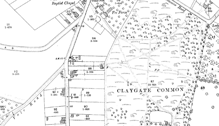
In the latter part of the 19th century Fee Farm comprised about seven acres of which nearly three acres were orchards, and the rest mainly meadow and arable land. It had a cottage, the usual farm buildings and a paddock. The area covered by the farm was bounded on the east by The Causeway and Coverts Road, on the south and north by what later became Woodlands Close and Cornwall Avenue respectively, and on the west by Claygate Common. It is quite possible of course that the farm was somewhat larger in earlier times, as in 1838, when James Scott was the tenant, the farm had a rateable value of £21 which would have been rather excessive for a farm of that size.
On the farmland, opposite the 'Corner Shop' and roughly where the house called 'Two Trees' now stands, was a smith's shop and a yard built some time before 1709 by John Romain. In 1709 it was occupied by the widow of Richard Perkins for a yearly rent of 2s.6d. for 41 years, subsequently by William Wood, then by John Woodlatch, and finally by Stephen Humphrey who obtained a seven-year lease of the shop in September 1893. In that year, and for at least the previous 20 years, James Taylor was the tenant farmer, but in the following year Edward Dalton took over the tenancy, while the Foley family were the landlords.
In April 1920, Lord Gerald Henry Foley sold Fee Farm and its land, including the shop, to George and Rundle Brendon for £1,300. They in turn sold it to Percy and Charles Mitchell of Seaton, Devon, for £2,750 in October 1923. The Mitchell brothers were builders and in the late 1920s/1930s Fee Farm Road was created, but not made up, and houses were gradually built along either side of it. Fortunately, the farmhouse itself survived and was not demolished for redevelopment as might easily have been the case in those days when the preservation of old buildings was not so controlled as it is today.
In the mid 1930s, a strip of land on the northern boundary of the farm was acquired by Esher Urban District Council to create an easier and safer access to Common Road from The Causeway. This short stretch of road was built in 1938 and named Cornwall Avenue after an adjacent house called Cornwall House, which together with Newlyn, had been built two years beforehand. Most of the houses along this road were given West Country names, presumably either at the inspiration of the Mitchells who came from Devon, or perhaps because the householders thought that West Country names would harmonise with the name of this road.

Source
- Peebles, Malcolm (1983). The Claygate Book. (Millennium edition). Stockbridge: by BAS Printers Ltd. ISBN 0-9508978-0-9.

- Many thanks also for the photos, many supplied by Terry Gale, from the Claygate Local History Facebook group.
The Winning Horse

Deeds of the site on which 'The Winning Horse' stands state that this was wasteland in 1818, 1845 and 1850; so too does an Ordnance Survey map of 1866. The first mention of 'The Winning Horse' public house appears in a deed of 1897, which is presumably when it was built. In 1913 the pub was purchased by Brandons Putney Brewery who sold it to Mann, Crossman and Paulin Ltd in 1950.
| INTERESTING FACT
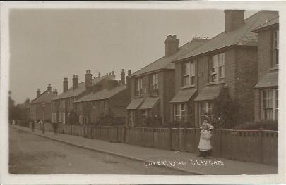
Until 1933, Coverts Road was known as Covers' Road. |
It could be that 'The Winning Horse' was first owned and named by someone who had a lively interest in horse racing. During the inter-war period a horse-race course on Claygate Common, a short walk from 'The Winning Horse', could have given rise to its name.
Shops in the Coverts Road area
At the junction of Church Road and Coverts Road, stands the aptly named Corner Shop. Originally a cottage, this was a general provision store and tobacconist for many years. For over 20 years it was run by Frank Summers, who even at 82, opened his shop seven days a week for the sale of tobacco and confectionery. His predecessor, Miss Ethel Bowyer, was also regarded with great affaction.
Next door to the Corner Shop (2 Foley Road) was Claygate's only cycle shop, complemented by petrol dispensing facilities. This business was started in 1908 and remained in the hands of the Edwards family for 65 years, passing from father to son to grandson, until the latter, the late Frank Edwards, retired at the age of 65 in 1973. The business was then sold to Brian Hansford. In the early days, the founder made his own bicycle frames and had a forge at the back of the shop. Frank Edwards started as an apprentice at the age of 12 in 1923 and took over the business from his father in 1943. The Edwards family also began a taxi service in 1918 and this operated successfuly for more than 30 years.
From even a cursory look at 2 Foley Road and the adjoining premises (number 4) one can see that the facades are quite different, although they were originally built at the same time. This is because the Edwards premises were substantially destroyed by fire and rebuilt in a more modern style. Number 4 was variously a butcher, grocer and ladies hairdresser over the years.

