Telegraph Lane
| H I N C H L E Y W O O D | ||||||||
| E | 
|

|

|

|

|

|
C | |
| S | 
|

|

|

|

|

|
H | |
| H | 
|

|

|

|

|

|
E | |
| E | 
|

|

|

|

|

|
S | |
| R | 
|

|

|

|

|

|
S | |

|

|

|

|

|

|
N | ||
| O X S H O T T | ||||||||
2024 Planning Applications
№ 14
ADDRESS: 14 Telegraph Lane
|
№ 63
| ADDRESS: 63 Telegraph Lane
Comment re obscure glazing
|
№ 73
| ADDRESS: 73 Telegraph Lane
|
| ADDRESS: 73 Telegraph Lane
|
| ADDRESS: 73 Telegraph Lane
|
| ADDRESS: 73 Telegraph Lane
|
Historical Notes
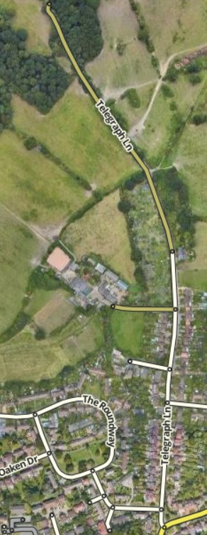
For many years there was a track which led from Red Lane, passed Slough Farm and skirted round the western slopes of Telegraph Hill. From there it went in a northerly direction, across a country lane (later to become Manor Road South), to link up with Portsmouth Road near the Scilly Isles. It is unlikely that this track could have been used by vehciles along its entire length, because when the railway was built in the 1880s only a footbridge was provided to cross the line.
When Semaphore House was built, the southern section of this track, with a branch constructed to the top of the hill, was called Telegraph Road, subsequently Telegraph Lane, while the northerly section fell gradually into disuse.
Near the junction with Red Lane used to be Upper Couchmore Farm, subsequently known as Green Farm, before its demise when Langbourne Way and Crediton Way were built. Further up on the west side before one reaches Slough Farm was originally a corn chandler's shop and known previously as Ivy Cottage, now № 41 and a private residence, and nearby on the site occupied by Applegarth were two other shops, one of which was a butcher's shop. The last dwellings on the east side of Telegraph Lane — Orchard Cottages — were built in 1883.
During the 1920s and 1930s much infilling along existing roads took place, together with the development of new roads and housing estates such as Meadow Road, Torrington Road, Dalmore Avenue, Cornwall Avenue and Hillview Road. Building came to a stop during the Second World War, and did not get underway again until the 1950s when the Slough Farm council estate between Telegraph Lane and Oaken Lane was built, as also were the much smaller estates of Rosehill and Fairlawn Close which took their names from the old houses they replaced.
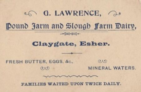
Claygate had several farms in centuries past. There was Beazley Farm by Littleworth Common which ceased milk production in the 1950s in favour of horses; Slough Farm had a dairy herd of Red Poll Cattle and later pigs but later had horses; Manor Farm had a dairy herd of prize-winning jersey cows but later had horses; Elm Farm had dairy cows and chickens and sold delicious cream, but later had a plant nursery business and horse-feed shop; Barwell Court had a big herd of Friesian milking cows and grew cereals, but later kept horses; Horringdon Farm had one of the last big dairy herds of Red Poll cattle and grew cereals and potatoes, but but later horses and grazes young cattle for Loseberry Farm; Loseberry Farm no longer keeps a dairy herd; it later kept a house cow and young stock for the dairy herd at Stoke D'Abernon.
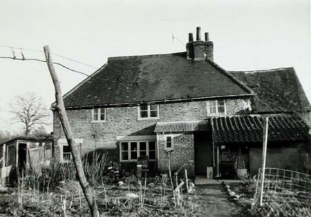
- Slough Farm, Telegraph Lane. The farmhouse bears a Sun Insurance Fire Mark No. 599538 issued on 24th April 1792 to the owner, Elizabeth Barwick of Hertfordshire. Arguably, Merrilyn and Slough Farmhouse are Claygate's two oldest properties.
Green Farm and Upper Couchmore Farm
In the early 20th century, Green Farm was a small arable farm of nearly 14 acres lying between Telegraph Lane and Claygate Lane with the farmhouse sited on the south-eastern corner where Telegraph Lane and Red Lane meet. It adjoined the much larger Upper Couchmore Farm, both of which comprised part of the Couchmore Estate, totalling about 335 acres and owned for many years by the Banks family. Part of Upper Couchmore Farm also stretched into property owned by the Speer family.
In 1838, Francis Elworthy was the tenant farmer of Green Farm which was valued for rating purposes at £94.10s.0d., while William Whiston was the tenant of Upper Couchmore Farm valued at £111. Isaac Dagwell is recorded as the tenant of Green Farm in 1843.
The Ordnance Survey map of 1866 marks Upper Couchmore Farm at the corner of Telegraph Lane and Red Lane, but there is no reference to Green Farm, although other documents still show Francis Elworthy as the tenant of that farm. The reverse situation applies in Ordnance Survey maps published after the First World War. Deeds state that Richard Brice obtained on 29th September 1890 an optional lease on Green Farm of 7, 14 or 21 years' duration for a yearly rent of £100 with apportioned tithes, paid by the landlord, of £10.5s.7d. —Brice was still there until at least 1926.
In February 1936, Green Farm was sold to Tom Knights of the Foley Arms as principal purchaser for £6,000, with Davis Estates Limited as sub-purchaser until they subsequently became the main owner. A few houses were built in the late 1930s along the east side of Telegraph Lane, but it was not until the 1950s that Davis Estates of Kilburn, London, proceeded to develop the housing estate that now comprises Langbourne Way and Crediton Way. Most of the semi-detached houses with garages on this estate were built in 1954 and 1955 and were sold for about £3,000 each.
Slough Farm

The Sun Insurance Fire Mark was issued to the owner of Slough Farm, Elizabeth Barwick of Clare Hill, South Mimms, Hertfordshire, on 24th April 1792, when James Scott was the tenant farmer. According to this policy the farmhouse was built of brick and timber and tiled and valued at £200. There was a barn and cowhouse valued at £100; a stable and carthouse at £60; another barn at £70; a timber and tiled granary at £30; two brick and timber tiled cottages at £30 each, and a shed and a barn in a nearby field valued at £10 and £60 respectively. Except where noted, all these buildings were thatched.

The farmland lies either side of Telegraph Lane extending up the southern flanks of Telegraph Hill. Today it comprises approximately 100 acres, but was rather larger thirty years ago when the western part of the farm was developed as a council housing estate comprising 116 houses of 10 different types for 400 to 500 people — what is now The Roundway area.
Since 1801 the farm has been owned by the Speer (Litchfield) family who acquired the Manor of Weston Green at that time. Past tenants have included: Henry Stent (recorded as tenant in 1874 and 1926) and John Keen (1938), who also ran a dairy at No. 5 High Street for several years, while Edward Telling became the tenant in 1945. In earlier times the farm was devoted mainly to dairy cattle, but later it concentrated on pig-rearing, while the greater part of the land was used for horse-grazing and the growing of hay for privately-owned horses that it could stable.
See also
Sources
- Claygate Heritage Trail, (leaflet produced by Claygate Parish Council)
- Peebles, Malcolm (1983). The Claygate Book. (Millennium edition). Stockbridge: by BAS Printers Ltd. ISBN 0-9508978-0-9.

- Many thanks also for the photos, many supplied by Terry Gale, from the Claygate Local History Facebook group.
- Claygate Life — 2004 issue 4

